On the summit of an isolated ridge in the parish of Llanbedr stand the remains of the prehistoric hillfort known as Clogwyn Arllef. The dimensions are roughly 70 metres in diameter from north to south, and 55 metres form west to east. The remains are defined by fallen stone wall which is an average of 2 metres wide.
The intriguing Saint Tanwg’s Church is situated in the sand dunes at Llandanwg, which is at the mouth of the River Artro, opposite to Mochras (Shell Island).
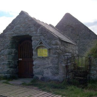
This mountain lake is situated within the Carneddau range in Snowdonia. The lake has an area of approximately 6 acres, is 250 metres long and is overshadowed by the peaks of Pen yr Ole Wen (the seventh highest peak in Wales (3209 feet)) and Carnedd Dafydd (the third highest peak in Wales (3425 feet)).
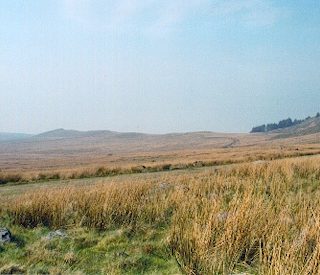
Craig-y-Dinas hillfort can be found due east of Dyffryn Ardudwy, overlooking Llyn Irddyn. It is at the summit of a prominent rocky outcrop (1150 feet) and is polygonal in shape and has dimensions of approximately seventy metres by forty metres (0.5 acres).
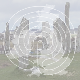
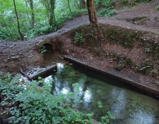
Situated in a copse approximately 200 yards West of Eglwys St. Dyfnog, with access via a gate in the graveyard, is Ffynnon Dyfnog, (the well of Saint Dyfnog) which is a rectangular stone bath (18 inches deep) fed by a spring.
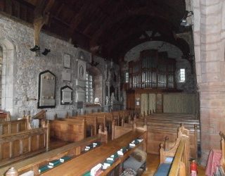
Llanrhaeadr-yng-Nghinmeirch is a village in the Vale of Clwyd, approximately five kilometres to the South-East of Denbigh on the A525. The village church, Eglwys St. Dyfnog is a historic building, having a double nave, a 13th Century tower and an exquisite Medieval ‘Tree of Jesse’ window of superb design and glass quality.
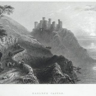
Much of the Mabinogion saga is based in the Ardudwy region of North Wales. It was from the ‘Castle Rock’ or ‘Rock of Harlech’ (where Harlech Castle now stands) that the Welsh King Bendigeidfran first saw the Irish longboats of Matholwch loom into view with their shields turned upside down as a sign of peace.
The Groes Las settlement between Harlech and Llanfair was a domestic agricultural homestead in prehistory. It consists of the remains of a hut circle with walls approximately 3.0 metres thick and up to 1.2 metres high.
This standing stone found close to Merthyr Farm, Harlech, is the tallest and most prominent of the five stones denoting the supposed prehistoric track way known as Fonlief Hir. The stone stands just over six feet tall and can be seen over a gate in the stone farm wall beside the road.
Bedd Gorfal is also known as the Harlech stone circle and is situated close to the ancient Fonlief Hir track way. There are eight stones in the four metre diameter circle, five of them are easily visible and three are small and easily overlooked. The tallest stone is only about one metre tall, and it is split.
Our Mysterious Britain & Ireland site uses cookies to improve your experience. We assume you are ok with this, but you can opt-out if you wish. AcceptRead More
Privacy & Cookies Policy
Privacy Overview
This website uses cookies to improve your experience while you navigate through the website. Out of these cookies, the cookies that are categorized as necessary are stored on your browser as they are essential for the working of basic functionalities of the website. We also use third-party cookies that help us analyze and understand how you use this website. These cookies will be stored in your browser only with your consent. You also have the option to opt-out of these cookies. But opting out of some of these cookies may have an effect on your browsing experience.
Necessary cookies are absolutely essential for the website to function properly. This category only includes cookies that ensures basic functionalities and security features of the website. These cookies do not store any personal information.
Any cookies that may not be particularly necessary for the website to function and is used specifically to collect user personal data via analytics, ads, other embedded contents are termed as non-necessary cookies. It is mandatory to procure user consent prior to running these cookies on your website.
Recent Comments